Your web browser is no longer supported. To improve your experience update it here
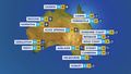
MELBOURNE Weather
11Showers
Feels like8
Max12
Min7
- Rain chance: 90%
- Wind: SW 7km/h
- Rainfall: 0mm
- Humidity: 79%
- UV Alert: Low
Hourly forecast
Weekly weather
MELBOURNE rain radar map
11:25 AEST11:30 AEST11:35 AEST11:40 AEST11:45 AEST11:50 AEST


10:40 AEST10:50 AEST11:00 AEST11:10 AEST11:20 AEST11:30 AEST


View Victoria satellite

View national synoptic
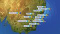
Weather warnings
Severe Weather Warning (Damaging Winds) for parts of West and South Gippsland, Central and South West
Australian Government Bureau of Meteorology Victoria TOP PRIORITY FOR IMMEDIATE BROADCAST Severe Weather Warning for Damaging Winds for parts of West and South Gippsland, Central and South West Forecast Districts. Issued at 10:54 am Sunday, 14 July 2024. Damaging winds developing along parts of the southwest facing southern coasts and Mt Baw Baw from Monday afternoon. Weather Situation A complex low pressure system currently lies to the northeast of Tasmania. This low is forecast to track towards the Bass Strait during Monday, with a series of associated troughs crossing Victoria, resulting in strengthening southwesterly winds along parts of the coastline and Mt Baw Baw. DAMAGING WINDS for the following areas: Central, South West and West and South Gippsland For parts of the SOUTHWEST FACING SOUTHERN COASTS: DAMAGING WINDS averaging 60 to 70 km/h with peak gusts of around 90 km/h are possible for parts of the coastal fringe extending from Port Campbell to Wilsons Promontory from late Monday afternoon, easing overnight. For MT BAW BAW: Strong winds averaging 50 to 60 km/h with DAMAGING WIND GUSTS of around 90 km/h are possible from the early afternoon, easing overnight. Locations which may be affected include Wonthaggi, Rosebud, Tidal River and Mt Baw Baw. The State Emergency Service advises that people should: * If driving conditions are dangerous, safely pull over away from trees, drains, low-lying areas and floodwater. Avoid travel if possible. * Stay safe by avoiding dangerous hazards, such as floodwater, mud, debris, damaged roads and fallen trees. * Be aware - heat, fire or recent storms may make trees unstable and more likely to fall when it's windy or wet. * Check that loose items, such as outdoor settings, umbrellas and trampolines are safely secured. Move vehicles under cover or away from trees. * Stay indoors and away from windows. * If outdoors, move to a safe place indoors. Stay away from trees, drains, gutters, creeks and waterways. * Stay away from fallen powerlines - always assume they are live. * Be aware that in fire affected areas, rainfall run-off into waterways may contain debris such as ash, soil, trees and rocks. Heavy rainfall may also increase the potential for landslides and debris across roads. * Stay informed: Monitor weather warnings, forecasts and river levels at the Bureau of Meteorology website, and warnings through VicEmergency website/app/hotline. The next Severe Weather Warning will be issued by 5:00 pm AEST Sunday. Warnings are also available through TV and Radio broadcasts, the Bureau's website at www.bom.gov.au or call 1300 659 210. The Bureau and State Emergency Service would appreciate warnings being broadcast regularly.Severe Weather Warning (Damaging Winds) for parts of West and South Gippsland, Central and South West
Australian Government Bureau of Meteorology Victoria TOP PRIORITY FOR IMMEDIATE BROADCAST Severe Weather Warning for Damaging Winds for parts of West and South Gippsland, Central and South West Forecast Districts. Issued at 10:54 am Sunday, 14 July 2024. Damaging winds developing along parts of the southwest facing southern coasts and Mt Baw Baw from Monday afternoon. Weather Situation A complex low pressure system currently lies to the northeast of Tasmania. This low is forecast to track towards the Bass Strait during Monday, with a series of associated troughs crossing Victoria, resulting in strengthening southwesterly winds along parts of the coastline and Mt Baw Baw. DAMAGING WINDS for the following areas: Central, South West and West and South Gippsland For parts of the SOUTHWEST FACING SOUTHERN COASTS: DAMAGING WINDS averaging 60 to 70 km/h with peak gusts of around 90 km/h are possible for parts of the coastal fringe extending from Port Campbell to Wilsons Promontory from late Monday afternoon, easing overnight. For MT BAW BAW: Strong winds averaging 50 to 60 km/h with DAMAGING WIND GUSTS of around 90 km/h are possible from the early afternoon, easing overnight. Locations which may be affected include Wonthaggi, Rosebud, Tidal River and Mt Baw Baw. The State Emergency Service advises that people should: * If driving conditions are dangerous, safely pull over away from trees, drains, low-lying areas and floodwater. Avoid travel if possible. * Stay safe by avoiding dangerous hazards, such as floodwater, mud, debris, damaged roads and fallen trees. * Be aware - heat, fire or recent storms may make trees unstable and more likely to fall when it's windy or wet. * Check that loose items, such as outdoor settings, umbrellas and trampolines are safely secured. Move vehicles under cover or away from trees. * Stay indoors and away from windows. * If outdoors, move to a safe place indoors. Stay away from trees, drains, gutters, creeks and waterways. * Stay away from fallen powerlines - always assume they are live. * Be aware that in fire affected areas, rainfall run-off into waterways may contain debris such as ash, soil, trees and rocks. Heavy rainfall may also increase the potential for landslides and debris across roads. * Stay informed: Monitor weather warnings, forecasts and river levels at the Bureau of Meteorology website, and warnings through VicEmergency website/app/hotline. The next Severe Weather Warning will be issued by 5:00 pm AEST Sunday. Warnings are also available through TV and Radio broadcasts, the Bureau's website at www.bom.gov.au or call 1300 659 210. The Bureau and State Emergency Service would appreciate warnings being broadcast regularly.Sheep Graziers Warning for Northern Country, North Central, North East, South West, Central, West and South Gippsland and East Gippsland
Australian Government Bureau of Meteorology Victoria Warning to Sheep Graziers for Northern Country, North Central, North East, South West, Central, West and South Gippsland and East Gippsland forecast districts Issued at 10:49 AM EST on Sunday 14 July 2024 Warning to Sheep Graziers for the following areas: Northern Country, North Central, North East, South West, Central, West and South Gippsland and East Gippsland forecast districts Sheep graziers are warned that cold temperatures, rain and showers and westerly winds are expected during Monday. Areas likely to be affected include the South West, Central and West and South Gippsland forecast districts and parts of the Northern Country, North Central, North East and East Gippsland forecast districts. There is a risk of losses of lambs and sheep exposed to these conditions. The next warning will be issued by 5:00 pm EST Sunday.Gale Warning for East Gippsland Coast. Strong Wind Warning for Central and Central Gippsland coasts
Australian Government Bureau of Meteorology Victoria Marine Wind Warning Summary for Victoria Issued at 10:00 AM EST on Sunday 14 July 2024 for the period until midnight EST Monday 15 July 2024 Wind Warnings for Sunday 14 July Gale Warning for the following areas: East Gippsland Coast Strong Wind Warning for the following areas: Central Coast and Central Gippsland Coast Wind Warnings for Monday 15 July Gale Warning for the following areas: West Coast, Central Coast, Central Gippsland Coast and East Gippsland Coast Strong Wind Warning for the following areas: Port Phillip, Western Port and Gippsland Lakes The next marine wind warning summary will be issued by 4:40 pm EST Sunday. ================================================================================ Check the latest Coastal Waters Forecast or Local Waters Forecast at http://www.bom.gov.au/vic/forecasts/map.shtml for information on wind, wave and weather conditions for these coastal zones. ================================================================================
National weather
Weather Articles
Data supplied byWeather Zone