Your web browser is no longer supported. To improve your experience update it here
HOBART Weather
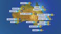
8Wind and rain increasing
Feels like2
Max10
Min3
- Rain chance: 90%
- Wind: S 28km/h
- Rainfall: 0.6mm
- Humidity: 81%
- UV Alert: Low
Hourly forecast
Weekly weather
HOBART rain radar map
11:20 AEST11:25 AEST11:30 AEST11:35 AEST11:40 AEST11:45 AEST


10:40 AEST10:50 AEST11:00 AEST11:10 AEST11:20 AEST11:30 AEST


View Tasmania satellite

View national synoptic
Weather warnings
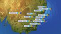
Severe Weather Warning (Damaging Winds) King Island & Western, South East, North East, East Coast, NW Coast, CN, C Plateau & Midlands
Australian Government Bureau of Meteorology Tasmania TOP PRIORITY FOR IMMEDIATE BROADCAST Severe Weather Warning for Damaging Winds for King Island and parts of Western, South East, North East, East Coast, North West Coast, Central North, Central Plateau and Midlands Forecast Districts. Issued at 10:55 am Sunday, 14 July 2024. Damaging winds to develop from the late afternoon today and continue into Monday. Weather Situation A deep low pressure system is situated to the east in the Tasman Sea and is slowly approaching the state overnight before reaching close to the east coast during Monday. This will increase the south to southwesterly pressure gradient over the state, bringing areas of strong to damaging winds over eastern and central parts of the state during Sunday afternoon and evening, before extending the risk to western coastal areas and King Island during Monday. Conditions are expected to ease later on Monday as the low weakens and slowly moves to the north into Bass Strait. DAMAGING WINDS for the following areas: King Island, Western, South East, North East, East Coast, North West Coast, Central North, Central Plateau and Midlands For the exposed coasts and islands in the SOUTHEAST: South to southwesterly DAMAGING WINDS averaging 60 to 70 km/h with gusts up to 100 km/h are likely to develop from late Sunday afternoon and continue through into early Monday morning, easing by sunrise. For the WESTERN TIERS and elevated terrain in the NORTHEAST: South to southwesterly DAMAGING WINDS averaging 60 to 70 km/h with peak gusts up to 120 km/h are likely to develop from early Sunday evening. Winds are expected to ease during the late morning or early afternoon on Monday. For the WEST COAST and KING ISLAND: South to southwesterly DAMAGING WINDS averaging 60 to 70 km/h with gusts up to 100 km/h are likely to develop about coastal areas of the Western district before sunrise on Monday and extend to the far western parts of the North West Coast district and King Island later in the morning. Winds are likely to ease during the evening. Locations which may be affected include Currie, Sheffield, Deloraine and Strahan. The State Emergency Service advises that people should: * Supervise children closely. * Check that family and neighbours are aware of warnings. * Manage pets and livestock. * Secure outdoor items including furniture and play equipment. * Be prepared in case of power outages and report any outages to TasNetworks on 132 004. * Beware of damaged trees and power lines and take care when driving. * Listen to the ABC radio or check www.ses.tas.gov.au for further advice. * For emergency assistance contact the SES on 132500. The next Severe Weather Warning will be issued by 5:00 pm AEST Sunday. Warnings are also available through TV and Radio broadcasts, the Bureau's website at www.bom.gov.au or call 1300 659 210. The Bureau and State Emergency Service would appreciate warnings being broadcast regularly.Severe Weather Warning (Damaging Winds) King Island & Western, South East, North East, East Coast, NW Coast, CN, C Plateau & Midlands
Australian Government Bureau of Meteorology Tasmania TOP PRIORITY FOR IMMEDIATE BROADCAST Severe Weather Warning for Damaging Winds for King Island and parts of Western, South East, North East, East Coast, North West Coast, Central North, Central Plateau and Midlands Forecast Districts. Issued at 10:55 am Sunday, 14 July 2024. Damaging winds to develop from the late afternoon today and continue into Monday. Weather Situation A deep low pressure system is situated to the east in the Tasman Sea and is slowly approaching the state overnight before reaching close to the east coast during Monday. This will increase the south to southwesterly pressure gradient over the state, bringing areas of strong to damaging winds over eastern and central parts of the state during Sunday afternoon and evening, before extending the risk to western coastal areas and King Island during Monday. Conditions are expected to ease later on Monday as the low weakens and slowly moves to the north into Bass Strait. DAMAGING WINDS for the following areas: King Island, Western, South East, North East, East Coast, North West Coast, Central North, Central Plateau and Midlands For the exposed coasts and islands in the SOUTHEAST: South to southwesterly DAMAGING WINDS averaging 60 to 70 km/h with gusts up to 100 km/h are likely to develop from late Sunday afternoon and continue through into early Monday morning, easing by sunrise. For the WESTERN TIERS and elevated terrain in the NORTHEAST: South to southwesterly DAMAGING WINDS averaging 60 to 70 km/h with peak gusts up to 120 km/h are likely to develop from early Sunday evening. Winds are expected to ease during the late morning or early afternoon on Monday. For the WEST COAST and KING ISLAND: South to southwesterly DAMAGING WINDS averaging 60 to 70 km/h with gusts up to 100 km/h are likely to develop about coastal areas of the Western district before sunrise on Monday and extend to the far western parts of the North West Coast district and King Island later in the morning. Winds are likely to ease during the evening. Locations which may be affected include Currie, Sheffield, Deloraine and Strahan. The State Emergency Service advises that people should: * Supervise children closely. * Check that family and neighbours are aware of warnings. * Manage pets and livestock. * Secure outdoor items including furniture and play equipment. * Be prepared in case of power outages and report any outages to TasNetworks on 132 004. * Beware of damaged trees and power lines and take care when driving. * Listen to the ABC radio or check www.ses.tas.gov.au for further advice. * For emergency assistance contact the SES on 132500. The next Severe Weather Warning will be issued by 5:00 pm AEST Sunday. Warnings are also available through TV and Radio broadcasts, the Bureau's website at www.bom.gov.au or call 1300 659 210. The Bureau and State Emergency Service would appreciate warnings being broadcast regularly.Sheep Graziers Warning for Midlands, South East & East Coast. Cancellation of Sheep Graziers Warning for Furneaux Islands
Australian Government Bureau of Meteorology Tasmania Warning to Sheep Graziers for Midlands, East Coast and South East forecast districts Issued at 10:49 AM EST on Sunday 14 July 2024 Warning to Sheep Graziers for the following areas: Midlands, East Coast and South East forecast districts Sheep graziers are warned that cold temperatures, rain and showers and strong southwesterly winds are expected during Sunday and Monday. Areas likely to be affected include parts of the Midlands, East Coast and South East forecast districts. There is a risk of losses of lambs and sheep exposed to these conditions. Cancellation of Warning to Sheep Graziers for the following areas: Furneaux Islands forecast district The Warning to Sheep Graziers for the Furneaux Islands forecast district has been cancelled. The next warning will be issued by 5:00 pm EST Sunday.Gale Warning East of Flinders Is, Derwent, Fred Hen Bay & Norfolks, Storm Bay, Channel & Far NW, Upper East, Lower E, SE, SW & CW coasts
Australian Government Bureau of Meteorology Tasmania Marine Wind Warning Summary for Tasmania Issued at 10:00 AM EST on Sunday 14 July 2024 for the period until midnight EST Monday 15 July 2024 Wind Warnings for Sunday 14 July Gale Warning for the following areas: Derwent Estuary, Frederick Henry Bay and Norfolk Bay, Storm Bay, Channel, Far North West Coast, East of Flinders Island, Upper East Coast, Lower East Coast, South East Coast, South West Coast and Central West Coast Strong Wind Warning for the following areas: Central Plateau Lakes, Central North Coast and Banks Strait and Franklin Sound Wind Warnings for Monday 15 July Gale Warning for the following areas: Far North West Coast, Central North Coast, East of Flinders Island, Upper East Coast, Lower East Coast, South East Coast, South West Coast and Central West Coast Strong Wind Warning for the following areas: Derwent Estuary, Frederick Henry Bay and Norfolk Bay, Storm Bay, Channel, Central Plateau Lakes and Banks Strait and Franklin Sound The next marine wind warning summary will be issued by 4:05 pm EST Sunday. ================================================================================ Check the latest Coastal Waters Forecast or Local Waters Forecast at http://www.bom.gov.au/tas/forecasts/map.shtml for information on wind, wave and weather conditions for these coastal zones. ================================================================================
National weather
Weather Articles

Data supplied byWeather Zone